UPDATE (Monday): Boulder 2700 Fire re-entry area expanded
Boulder 2700 Fire Monday update
Re-Entry for Residents North of Boulder 2700 Fire Area Near Mile Marker 11 up to Mile Marker 13.5
Beginning at 10 a.m. Monday, Aug. 9, the Lake County Sheriff’s Office will be allowing re-entry for residents who have property just north of the fire area near mile marker 11 up to mile marker 13.5 near Blue Bay along Highway 35. Mission Valley Power is working to restore power to this area. The Sheriff’s highway closure checkpoint will be located at mile marker 11. Access to and from this area will only be from north of the Boulder 2700 fire, coming south on Highway 35 from Bigfork. There is the potential for heavy fire vehicle traffic so everyone should drive slowly and carefully. The area directly affected by the fire from mile marker 9 to 11 remains evacuated due to post wildfire hazards including unstable and fire weakened hazard trees, rocks and rolling debris on slopes, fire trucks and equipment moving through the area, utility company equipment/employees working to repair or replace infrastructure, and unstable soils due to recent rains. Residents of the East Shore from mile marker 6 to 9 have been able to receive a re-entry permit since last week and can do so at the Finley Point checkpoint on Highway 35 south of the Boulder 2700 fire. East Shore Residents south of the fire (between mile marker 6 and 9) and north of the fire (between mile marker 11 and 13.5) remain in the "SET" stage of the “Ready, Set, Go” evacuation system and should be ready to leave at any time. Highway 35 remains closed to through traffic from Finley Point to Blue Bay to prevent the public from entering an active fire area, and to facilitate the safety and effectiveness of the firefighters working to contain the Boulder 2700 fire. The Highway 35 speed limit is lowered to 35 mph within the area past mile marker 2 to mile marker 15 to protect firefighters, utility company employees, and the public.
Inciweb: inciweb.nwcg.gov/incident/7754
Email: 2021.boulder2700@firenet.gov
Facebook: www.facebook.com/CSKT.Division.of.Fire
Information Phone: 406-530-5107
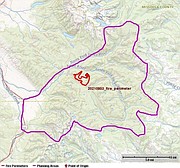
Location: 8 miles east of Polson
Estimated Size: 2,072 acres
Containment: 31%
Incident Command: Type 2 Northern Rockies Incident Management Team 4, Rick Connell, Incident Commander
Evacuations and Closures: Beginning at 10:00 a.m. this morning, the Lake County Sheriff’s Office will allow re-entry to properties outside of the fire perimeter and just north of the fire area near mile marker 11 up to mile marker 13.5 near Blue Bay. Mission Valley Power is working to restore power to this area. The Sheriff’s highway closure checkpoint will be at mile marker at 11. Access to and from this area will only be from the north of the Boulder 2700 fire, coming south on Highway 35 from Bigfork.
The area directly affected by the fire from mile marker 9 to 11 remains evacuated due to post-wildfire hazards including unstable and fire weakened hazard trees, rocks and rolling debris on slopes, fire trucks and equipment moving through the area, and utility company equipment/employees working to repair or replace infrastructure.
Residents of the East Shore from mile marker 6 to 9 can receive a re-entry permit at the Finley Point checkpoint on Highway 35 south of the fire. All residents in the re-entry areas of mile marker 6 through 9 and 11 through 13.5 remain in stage 2 (“SET”) evacuation status. Residents should be prepared to evacuate in the event fire activity increases.
Highway 35 remains closed to through traffic in both directions from Polson at the Highway 93/35 junction to Blue Bay mile marker 15. The speed limit is 35 mph within the area past mile marker 2 to protect firefighters and the public.
Sign up for Lake County Emergency alerts at: signup.hyper-reach.com/hyper_reach/sign_up_page_2/?id=95122
Current Status: The fire area received rain yesterday morning, with approximately one-half inch at Flathead Lake to 1.4 inches on eastern ridgelines. Minimal fire behavior was observed, with smoldering pockets of heat in the northeast area of the fire, and scattered smokes observed elsewhere. The rain event is described as wildfire season-slowing, not season-ending, as vegetation will dry out in days to weeks as drier, warmer weather returns. Crews patrolled the fire, checked structures, prepped containment and contingency lines, and continued mop up operations. Wind surges from area thunderstorms prevented air operations from working the fire yesterday.
Planned Actions: Night shift operations will cease, and efforts will be redirected towards addressing snags and other hazards around structures and roadways. Crews will work with structure protection specialists to thoroughly grid and secure structures within the fire area. Air operations will resume today and continue to check up the fire on the eastern flank. Utility companies and road crews will be working in the Highway 35 corridor.Weather today will be partly cloudy with a high near 70. Winds will be out of the west at 10-15 mph. Cooler temperatures will subside tomorrow as progressively hotter and drier weather returns Wednesday through the end of the week.
Temporary Boating Restriction (TBR): There is a TBR in place on Flathead Lake. No boats are allowed from Boulder Creek on the north to Station Creek on the south and one-half mile out from the shoreline. This restriction is in place to support the fire closure area as well as to provide a safe area on the lake for aircraft to pick up water.
Temporary Flight Restriction (TFR): There is a TFR in place for air space over the Boulder 2700 Fire (FDC 1-0786) to reduce impacts to fire aviation operations. Temporary flight restrictions also apply to unmanned aircraft systems (UAS) or drones. Drones are subject to the TFR. If you fly, we can’t!
Crooks Fire Monday update
There will be a community meeting at 6 p.m. Monday (Aug. 9) at the fitness center gym in Arlee.
Acres: 1,000
Cause: Lightning
Containment: 0%
Total personnel: 115
Start Date: July 21, 2021
Origin Location: 8 miles SE of Arlee, Montana
Fuels: Timber, forest litter, grass and shrubs
Incident Command: Local Type 3 organization, led by Art Trahan, Incident Commander, Robert D. McCrea (T)
Evacuations and Closures: St. Mary’s to the North Fork is closed; Main Jocko Road (1000 Rd) is closed at the 3000 Rd junction.
No structures are threatened, and no evacuation orders are in effect.
The Crooks fire started on July 21, 2021. The fire is located in the South fork Jocko Primitive Area and is burning in timber, forest litter, grass, and shrubs in steep, rough, road less terrain. Crooks Fire is burning thick standing and dead timber in the South Fork Jocko Primitive area of the Flathead Agency. Access is very limited. This area is designated to allow fire management to use fire as a management tool to sustain ecosystem values.
Fire activity during the last 48 hours was minimal thanks to some precipitation and cooler weather. Minimal fire behavior was observed, with smoldering pockets of heat on the north flank (Division B) of the fire. Firefighters and equipment are building control lines and clearing vegetation in Division A in the event the fire moves down into the Jocko valley.
Weather Outlook: Weather today will be partly cloudy with a high near 70. Hotter and drier weather returns on Wednesday through the end of the week.
Primary and Cooperating Agencies: Confederated Salish and Kootenai Tribes, Bureau of Indian Affairs, Lake County Sheriff’s Office, Lake County Office of Emergency Management, Montana Department of Natural Resources and Conservation, U.S. Forest Service
Sign up for Lake County Emergency alerts at: signup.hyper-reach.com/hyper_reach/sign_up_page_2/?id=95122
If you have questions or concerns regarding this notice, please contact Division of Fire at 676-2550 or contact C.T. Camel, Fire Information Officer, at 406-676-2550 ext. 6407 or email: ct.camel@cskt.org